
Agisoft Metashape
![]()
About Metashape
Agisoft Metashape is an advanced image-based 3D modeling solution aimed at creating professional quality 3D content from still images. Based on the latest multi-view 3D reconstruction technology, it operates with arbitrary images and is efficient in both controlled and uncontrolled conditions. Photos can be taken from any position, providing that the object to be reconstructed is visible on at least two photos. Both image alignment and 3D model reconstruction are fully automated.
Multiple Types of Images Input & Output Data
Process images from RGB or multispectral cameras, including multi-camera systems, in cloud-uri with dense points, polygonal models textured, real orthomosaics with Georeferinte and DSM/DTM.
Additional Post-processing allows the removal of shadows and artifacts from texture, calculation of vegetation indices and extraction of information for the action maps of agricultural equipment, automatic classification of clouds with dense points Etc.
Local or Cloud Processing
Agisoft Metashape can process over 50,000 photos from a local group due to distributed processing functionality. Alternatively, the project can be easily sent to the cloud to minimize hardware investment, and all processing options continue to be available.
Fast & Precise Accuracy
Based on the state-of-the-art technology developed by Agisoft, it allows for very fast processing, providing at the same time highly accurate results up to 3cm of accuracy for aerial photographs, and up to 1mm for close-range photography.
Intuitive User Interface & Stereo Mode
The software package has a linear project-based workflow that is intuitive and can be easily mastered even by a non-specialist. Professional photogrammetrists have the complete control over the results accuracy, thanks to a detailed report that is generated at the end of processing.
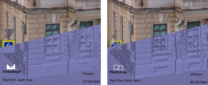
Highly detailed mesh generation based on depth maps
Improved filtering during dense stereo matching helps to reduce noise on the final surface while preserving thin structures within the scene. New depth map based mesh generation method works directly with depth maps data, which allows to reconstruct exceptionally detailed geometry thanks to utilization of all the information available. GPU acceleration support significantly speeds up the processing, while out of core implementation greatly reduces memory consumption compared to previous versions.
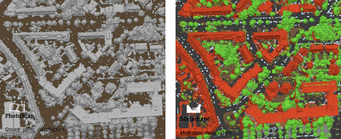
Automatic multi-class dense point cloud classification
Agisoft Metashape is enriched with machine learning techniques to solve the crucial task of higher- level interpretation of the scanned data. Semantic classification feature automatically groups photo- grammetric points into Ground, Vegetation, Building, Road, Car and Man-made classes.
Compatibility
- Support for digital cameras/film/video and multi-camera systems
- Processes images from frame/fisheye/spherical/cylindrical cameras
- Works well with most UAV devices
- Is integrated with LIDAR workflows with cloud import of points
- Export results to broad support formats
- Support for most coordinate systems and configurable vertical data systems
- Works in Windows, Mac OS X and Linux
Advantages
- Extremely accurate and detailed results
- Fully automatic and intuitive workflow
- GPU acceleration for faster processing
- Network processing for large projects
- Cloud processing for infrastructure saving
- Reasonably powerful Standard Edition for artistic projects
- Easy sharing with fast exporting PDF/fly through and direct upload to online resources
- Stereoscopic measurements for precise extraction of functions